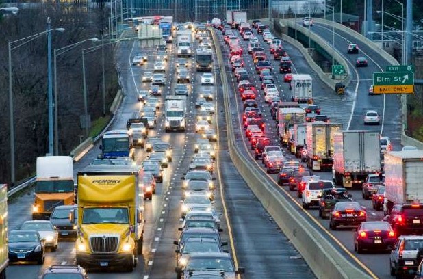
The stretch of I-95 that snakes through lower Fairfield County has a national reputation among transportation observers – and, sadly, it is not a good one. Indeed, a year rarely goes by when there aren’t two or three national surveys that cite this highway corridor as being among the least pleasant roadways in the U.S.
The most recent bad publicity came in February when the American Transportation Research Institute (ATRI) published its annual list of the nation’s most congested bottlenecks for trucks. Three Fairfield County locations made the top-100 list, all involving congestion on I-95 — 37th- ranked Stamford, 56th-ranked Norwalk and 79th-ranked Bridgeport.
Two months earlier, a pair of Fairfield County stretches of I-95 were cited as being among the 10 most congested roads in the 2021 Global Traffic Scorecard published by Inrix Inc., a provider of transportation analytics and connected car services. That report determined I-95 North in Bridgeport between Unquowa Road and NY-8 was the nation’s fourth most congested road, with peak delays lasting an average of 18 minutes and drivers losing an average of 72 hours per year, while I-95 North in Stamford between Riverside Avenue and Hillspoint Road was the sixth most congested road, with peak delays averaging 15 minutes and drivers losing an average of 61 hours per year.
“Despite being one of the smallest states, we know that Connecticut has some of the country’s worst congestion,” laments Joseph Sculley, president of the Motor Transport Association of Connecticut.
Just how did this section of I-95 become such a mess of endless traffic jams? The answer, it seems, lies in a long history involving a surplus of motorists and a deficit of prescient urban planners.
In the years before the automobile, the Boston Post Road was the main artery connecting New York City and Boston via the horse. Automobiles turned up in the early 20th century ,and the road was configured as a two-lane thoroughfare. But by the mid-1920s, the two-lane Boston Post Road was heavily congested with far more traffic than anticipated. Stop lights only added to the woes. According to Merrittparkway.org, the Connecticut Highway Department began a series of projects designed to improve the situation. From 1923 to ’31, parts of the road between the New York state line and New Haven were “widened to four lanes, straightened, repaved and even rerouted around congested town centers in a few places.”
While the Great Depression initially eased traffic, as few people could afford to maintain automobiles, Connecticut State Highway Commissioner John A. MacDonald realized the road would become clogged anew when the economy started to recover. And thus was born his idea for the Merritt Parkway, which opened in 1940. But that road was a limited-access, four-lane highway (two lanes north, two lanes south) that only accommodated passenger cars and would not host commercial traffic.
MacDonald also proposed a new road running parallel to the Post Road and the rail line that connected New York City to New Haven, which would be set aside for commercial traffic. That idea didn’t take root until 1953 when the governors of New York, Connecticut, Rhode Island and Massachusetts joined forces on a tolled highway running along the shoreline that would connect New York City to Provincetown, Massachusetts. The project was dubbed the Cape Code Expressway. Unlike MacDonald’s plan, it was designated for passenger and commercial vehicles.
Construction began in 1954 and the road was incorporated into the I-95 artery stretching from Maine to Florida with the passage of the Federal Aid Highway Act of 1956.
And that’s where today’s problems began. The Fairfield County section of the Connecticut Turnpike, as the state’s section of I-95 was dubbed, was designed for the traffic needs of 1958, when the roadway was opened. Its six lanes (three heading north, three heading south) had a capacity of 90,000 vehicles per day at the 60-miles-per-hour speed limit.
But within seven years of the highway’s opening, traffic exceeded its design capacity. Today, the Fairfield County corridor hosts approximately 130,000 vehicles per day. Expanding the highway to include additional lanes would prove infeasible. The state used eminent domain to seize private property to build the highway but never considered acquiring adjacent land in the event an expansion was needed.
One thing the highway originally enjoyed was financial self-sufficiency via eight toll barriers, including three in Fairfield County (Greenwich, Norwalk and Stratford). But many motorists complained that the tolls barriers contributed to congestion, and a January 1983 truck crash that killed seven people at the Stratford toll plaza resulted in successful efforts to have tolls removed by 1985. At the time, tolls contributed $65 million a year to the highway’s upkeep.
In June 1983, a section of the Mianus River Bridge linking Cos Cob and Riverside collapsed, killing three motorists. That sparked the first of multiple studies and projects designed to keep the highway safe. Billions of dollars in state and federal funds have gone into the highway’s upkeep, but calamities still exposed weaknesses — most notably when part of Bridgeport’s Howard Avenue collapsed in 2004 after a tanker truck hit a concrete barrier and spilled 9,000 gallons of fuel oil that caught fire.
An ambitious proposal emerged in February 2018 when then Gov. Dannel Malloy’s Connecticut Department of Transportation published a study that determined “limited, strategic widening” of I-95 in Fairfield County could “yield major benefits” without requiring the reconstruction of the existing highway. The project would have cost more than $2 billion, with funding by a 7-cent gas tax increase over four years and the introduction of electronic highway tolls. That effort went nowhere.
The latest push to decongest the highway is a $4-million study approved in January by the state Bond Commission offering a safety planning and environmental analysis of the road between Exits 19 in Fairfield and 27A in Bridgeport. But that study is not expected to be completed until sometime in 2023, and there is no guarantee that its recommendations will come to fruition.
And if the heavy traffic isn’t bad enough, there is also the surplus number of speed demons on the road — a situation that grew steadily worse during the Covid-19 pandemic.
“If you think it seems more dangerous out on Connecticut’s highways and interstates lately, you’re right,” Connecticut Department of Transportation Commissioner Joseph Giulietti observed last November. “It is a real crisis. It’s happening here and it’s happening across the country. We are seeing an unprecedented increase in fatalities.
“Combined with the speed and aggressive driving patterns since the start of the pandemic, we are pleading with Connecticut drivers to be more vigilant than ever,” Giuletti added. “We need to do everything we can to stop this trend.”